
Trust experienced Geophysical Surveyors for Solar Farms to identify underground hazards early, optimise design, and ensure smooth project delivery across the UK.
What is a Geophysical Survey for Solar Farms?
A geophysical survey for solar farms is a detailed study of the ground before any panels, cables or access tracks are built. Surveyors use non invasive equipment to scan below the surface and map changes in soil, rock and groundwater. Techniques can include ground penetrating radar, electrical resistivity, magnetometry and simple seismic tests.
The results show where the ground is strong, weak, voided or waterlogged. They can also highlight buried services, made ground and historic features. For solar developers, this early data helps shape the layout, pile design and cable routes. It also reduces surprises during construction, cutting delays, redesigns and costly on site repairs. By understanding the site properly from day one, projects can move forward with greater confidence.
Why Solar Projects Need Geophysical Surveyors
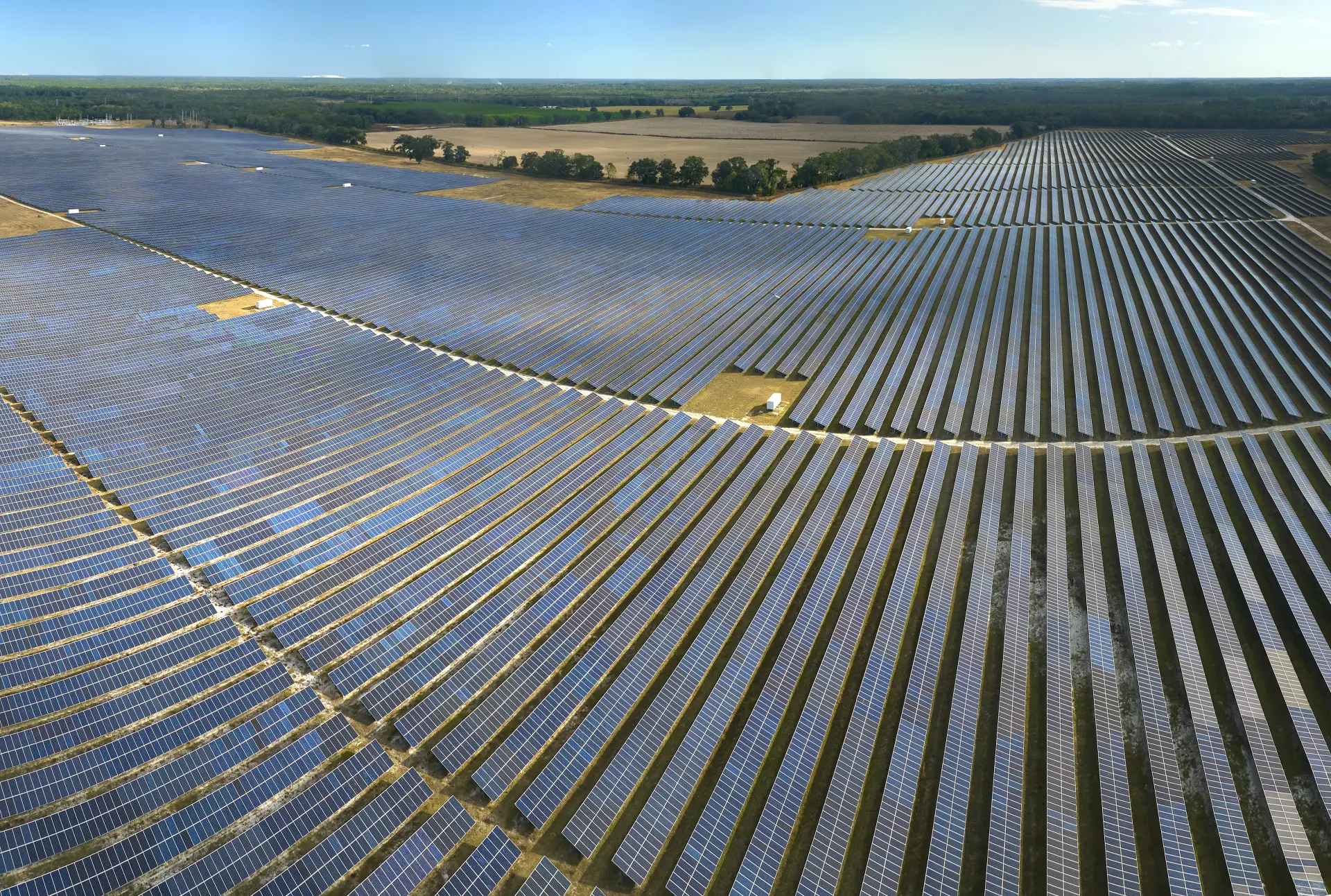
Solar projects need geophysical surveyors because the success of a farm depends on what lies beneath the surface, not just the land you can see. Ground conditions affect every major design decision, from pile depths and access roads to drainage, cable routes and substation locations. A specialist survey reduces guesswork and replaces it with measured data. That means fewer changes on site, fewer claims and a smoother build programme.
Geophysical surveyors bring experience with different soil types, geology and former land uses. They know how to select the right techniques for each part of the site, whether it is soft farmland, old quarry workings or made ground near an industrial area. Using tools such as ground penetrating radar and resistivity surveys, they can work quickly over large areas without disrupting farming activities.
For developers, investors and Pre-Construct Geophysics, early surveys support more accurate budgets and realistic construction schedules. For planners and landowners, they show that risks are understood and managed. In short, geophysical surveyors help keep solar projects safe, buildable and financially viable. Their reports can be shared easily with structural engineers, civil designers and ecological consultants, creating a common picture of the site. This collaboration helps to avoid clashes between trenches, access tracks, drainage runs and habitat areas.
When minor problems are found, designs can be adjusted on paper rather than in the middle of construction. When major problems are discovered, unsuitable areas can be avoided or removed from the scheme before large sums are committed. This protects everyone involved.
Finding Underground Risks before You Build
Finding underground risks before you build is one of the main reasons to use geophysical surveys on solar farms. Problems hidden in the ground can stop construction, damage equipment or reduce the life of the farm. Surveys help to spot buried services, old foundations, mine workings, sinkholes and pockets of soft or contaminated ground. They can also highlight zones of high groundwater or flooding.
Once mapped, these features can be avoided, protected or treated. This allows designers to refine pile layouts, cable routes and access tracks so they steer clear of hazards. Early discovery of these risks is far cheaper than emergency repairs during construction and helps keep workers, neighbours and the environment safe throughout the build and operation phase.
Protecting Cables, Piles and Foundations
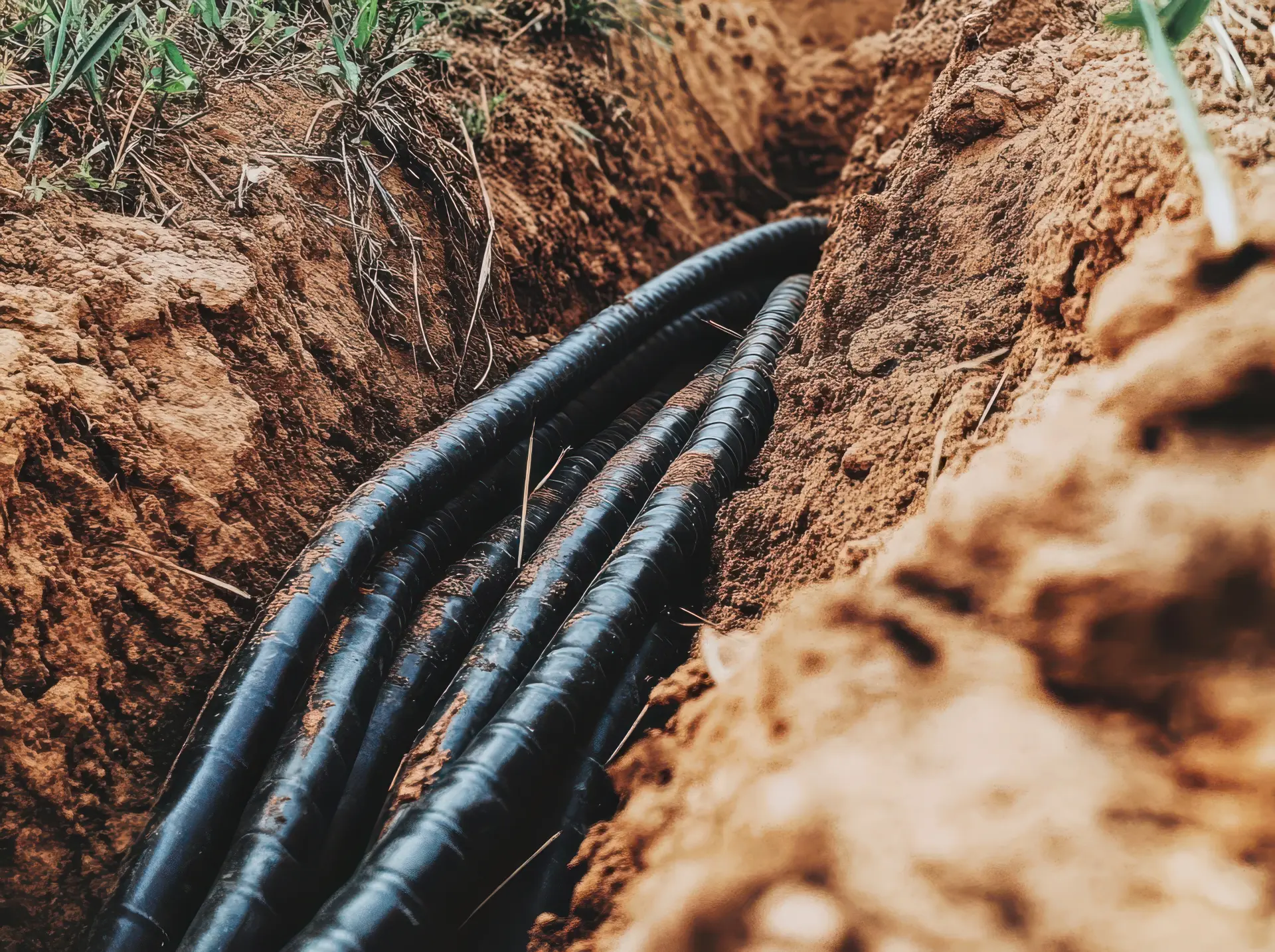
On a solar farm, buried cables, piles and foundations are some of the most valuable assets on site. Geophysical surveys help to protect them by giving engineers a clear picture of how the ground behaves and where special measures are needed. Information on soil strength, rock depth and groundwater levels can be used to choose the right pile type and length. This reduces the risk of movement, heave or long term settlement.
For cable routes, surveys can highlight suitable trenches with fewer boulders, obstructions or contaminated zones. They can also flag areas where cables may overheat if the soil is too dry, too wet or poorly compacted. With this knowledge, designers can adjust routes, cable sizes or bedding materials to keep temperatures under control.
As the project develops, geophysical data can be combined with load testing, trial pits and boreholes. Together, these datasets give a strong, evidence based foundation design. The result is a solar farm where structures, frames and cable systems are well matched to the ground conditions, helping to avoid failures, warranty claims and unplanned maintenance over the life of the site.
Early design reduces the chance that piles or foundations will clash with buried services, archaeology or sensitive habitats. When risks are identified, surveyors can work with designers to define exclusion zones or bespoke details. Examples might include shorter piles on embankments, reinforced pads near watercourses or alternative footing systems in soft ground. These targeted solutions keep the structure safe without adding cost elsewhere on the project.
How Surveys Help with Planning Permission
Geophysical surveys can be a valuable part of the planning package for a solar farm. Planning officers want to see that the developer understands the site and has taken reasonable steps to manage risk. Survey results can support flood risk assessments, land stability statements and construction method plans. They can also help address questions about buried services, contamination or historic land uses.
By showing where sensitive areas are, surveys guide designers to avoid them. This helps reduce objections, provides clear evidence for planning committees and can speed up planning permission decisions. Clear, illustrated reports make it easier for planners, consultees and residents to understand what is proposed, how the ground will be treated and why the layout has been chosen.
Geophysical surveyors use a range of tools and methods to explore the earth’s surface and subsurface. These surveys help understand physical properties such as rock properties and water levels without digging.
Geophysics supports many industries, including energy, archaeology, construction, and agriculture. Our approach ensures non intrusive and efficient surveying, helping clients make informed decisions about the land.